Tuesday, October 1, 2013

Dam removal done; planting underway

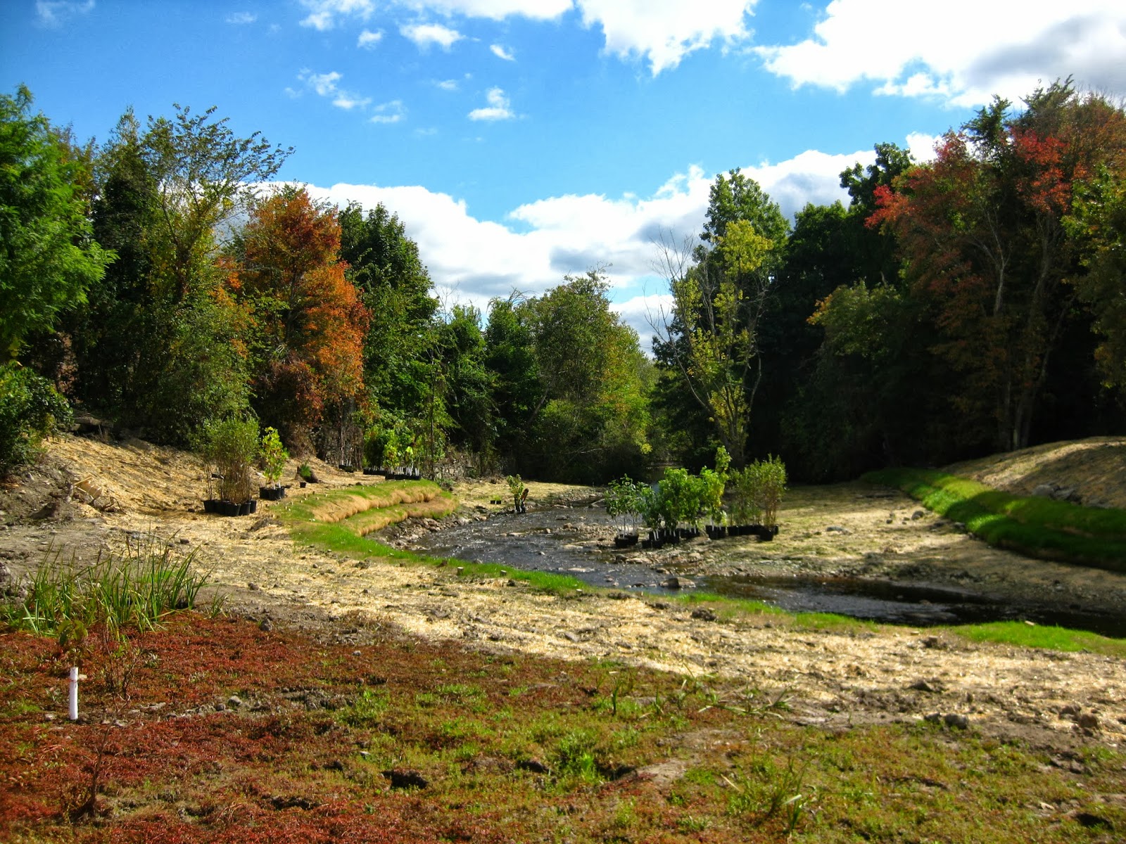
October, 2013 - The Whittenton Dam is gone, and SumCo restored the channel through the dam site.  The SumCo crews are nearly done with planting the new floodplain.  The plant list includes swamp white oak, red maple, silver maple, river birch, American elm, sycamore, Atlantic white cedar, sensitive fern, and hayscented fern, among others.  Below are before and after comparisons, photos of the plants, the new floodplain, and the completed channel work.


Looking downstream at Whittenton Dam, 2010
Same view, 2013.  Note natural regrowth in the foreground and completed channel restoration through the dam site
Looking downstream across the top of the dam, 2010

Similar view, 2013
Looking upstream from the dam removal site towards the restored floodplain.  
This picture shows some of the historic floodplain that was buried beneath the impoundment.  Note the tree stumps -- these are likely 200 years old.

Thursday, August 22, 2013

Channel construction and the return of floodplain vegetation

Now the construction crews are grading the stream banks and building soil burritos, or Fabric Encapsulated Soil lifts.  The lifts give the banks temporary stability while the trees and shrubs put down their roots.  Eventually, the fabric will biodegrade, and the roots will take over.


Meanwhile, plants are slowly returning to the former impoundment.  So far I've seen some native plants such as Golden Hedge Hyssop and some tiny red maple seedlings coming up.  A lot of purple loosestrife was already growing next to the Mill River before the dam was removed; you can see the purple haze in the background of these photos.


The Hopewell Mills site has been slow to green up in some places.  Here's a recent photo from last week of an area that recently sprouted vegetation, including purple loosestrife:

Tuesday, August 6, 2013

The Mill River finds its bed

Yesterday the Mill River was fed into its original bed through the former dam site.  To everyone's excitement, natural riverbed material (gravel, cobbles, sand, a few boulders) still lay beneath the tons of riprap, wood, and concrete that comprised the Whittenton Dam.  Check out a photo from today compared with the same view from 2010.

Here's today (looking downstream):


And here's September 2010:

The work goes quickly.  Here are a few shots of the construction work:
This photo is from a few days ago -- the channel is being constructed.  The photo below is from last week and shows the vast quantity of dam debris that had to be removed.


Wednesday, July 31, 2013

Removal of Whittenton Mill Dam

The Mill River continues to take back its channel and floodplain upstream of Whittenton Mill. This dam, the last one before the fish ladder at Lake Sabbatia, has come out in just one week, leaving the Reed & Barton dam as the last fish passage impediment on the river. This dam in particular has lived in its infamy as the dam that nearly flooded downtown Taunton during a storm in 2005. The partial failure of this dam set in motion the Mill River Restoration Project as well as many of the recent policy changes we have seen surrounding dams in both Massachusetts and Rhode Island.

It was with this history in mind that a press conference was held on July 19th to highlight the importance floodplain restoration, dam safety and habitat coming together in one important project. At this press conference, the first scoop was taken off the dam and it was clear from the speakers that our understanding of the hazards posed by dams to both our communities and our river systems has grown in recent years. This photo from The Nature Conservancy shows the first scoop. News coverage from the event includes ABC6 news in Providence, and the Taunton Gazette.

The original dam was constructed of concrete that lay on top of cedar timbers, with a timber spillway structure above. Rock was placed on the dam when it was partially removed in 2005. Now that the rock and timber have been removed, the river is back in its original channel which was revealed quickly after drawdown. Team members from DER and The Nature Conservancy assisted with the relocation of rare Eastern pondmussel from the upper impoundment into Lake Sabbatia.

In the coming weeks, stream bank construction, shaping of the flood plain and planting will be completed.


Wednesday, May 1, 2013

Beauty by the Mill River

Tim Watts found and photographed these trout lilies (Erythronium americanum) just downstream from the Hopewell Mills dam removal site.  Below is a poem from Tim.  According to historical documents, Cohannet was the name given by Native Americans to the first falls on the Mill River, perhaps in the vicinity of Hopewell Mills Dam.

Trout Lilies at Cohannet

I wandered up the stream bank to the tune of tumbling riffles, cardinals calling.
Sights and sounds familiar in a peculiar sort of way, all speaking. 
Speaking from sometime past, tickling  a tick of memory within. 
Mottled leaves at my feet, trout lilies, tender flowers bowing, being, beauty and grace.  
From beneath the canopy of maples I meander into morning sunlight. 
Winding away before me a ribbon of water unfurls, washing across gravel, unrestrained but buy the contour of cobble over bedrock beneath.
What is this place I ask?
I know the name given it by those that prospered from it. 
I know the name given it by those that labored for that prosperity. 
I know, I hear, I see something different now. 
I know she flows free.
I hear whispering in her riffles.
Mother Nature's patient laughter. 
Only time will tell her tale.
Together we shall see.

Tuesday, April 23, 2013

Watch the Mill River herring in action

The Massachusetts Division of Marine Fisheries (DMF) continues to catch Mill River herring and other resident fish on underwater video camera upstream from the Hopewell Mills Dam Removal site.  The first video shows river herring posing for the camera as they consider whether or not to swim into the monitoring trap.  The second video shows a trout (possibly eastern brook trout?) heading downstream.  Thanks to DMF's Mike Bednarski and Brad Chase for  this great monitoring project, funded by DMF, The Nature Conservancy, and NOAA's Open Rivers Initiative.


Thursday, April 4, 2013

The Fish are Back!

After 200 years, river herring have been spotted in the Mill River above the Hopewell Mills dam. The Division of Marine Fisheries recently set up a video monitoring station at Reed and Barton, and have been recording a stream of video footage. Many fish use the river, and from what has been reviewed, these fish include yellow perch, chain pickerel, trout and our first river herring!

Because this is a large project that includes removal of three dams and building a fish ladder, it provides a perfect opportunity to study the response of this river system to restoration efforts. Monitoring will continue with each removal, and a monitoring system will be put in place at the fish ladder as well. We will post video when it becomes available, and will continue to provide updates of fish sightings. For now, we are looking forward to seeing the new channel when grass begins to grow.


Thursday, December 13, 2012

Mill River to Mother Nature: "It's your turn, now."

12/11/12 - Today marked completion of human-led work at the Hopewell Mills Dam site, and the start of Mother Nature's lead role. 


 Photo 1: Mill River looking upstream through the former spillway site. Contractors installed tree trunks as bird perches on the floodplain.


Contractors planted the site last week with native trees and shrubs.  Hydroseeding took place today (that's the bright green you see in the photos).  Next week I'll add a few before - during - after photo sequences.  After that, the blog will take a break until the Whittenton Dam Removal Project begins upstream in few months.
   
 Photo 2&3: These pictures look downstream towards the former spillway.  In the photo above, logs and rootwads installed as habitat poke out of the stream bank.


Photo 4: This picture looks upstream from the former dam, across the impoundment, towards the Reed & Barton mill (brick buildings and smoke stack associated with the mill are in the distance).  The weird green color comes from the hydroseeding.


Wednesday, November 28, 2012

The last scoop

November 27, 2012 -- Today, RC&D removed the last scoop of sediment from the former mill pond.  The floodplain of the river is now revealed. 


Unlike what you might expect, the floodplain is not flat -- instead, it has gently sweeping highs and lows.  The engineers had included highs and lows in the design plans (referred to as "microtopography").  In the end, it was not necessary to build in the microtopography; it was already present in the natural contours.

 
Over the next week, landscapers will be planting the floodplain with native trees and shrubs, tailoring the location of the plants to the topography.  Plants that prefer wetter conditions will cluster in the low spots.  Those that thrive in slightly dryer conditions will sit on the gentle rises.  Next spring, as plants bloom or leaf out, this topographic variation will lead to a colorful mosaic.

Monday, November 5, 2012

What do the neighbors think?

The Mill River is lucky to have the Machado family watching out for it.  From their lawn at the upstream end of the former mill pond, the Machados have had a front-seat view of the dam removal project.  Every day, rain, shine, or hurricane, the Machados are outside watching the construction action.  They are familiar with every detail of the construction work.  On weekends, when the construction crews are at home, the Machados relocate fish and turtles from the construction site to nearby rivers and ponds. 

"This project is a dream come true," says Mr. Machado.  "I never thought I would see it happen in my lifetime".  He and his family enjoyed watching the swans, geese, ducks, and turtles that lived in the impoundment.  Now they are excited to see herring, kingfishers, ducks, herons, and eel return to the river in the spring.  We fully expect that the turtles will be back, too.


Here's the view from the Machado's lawn last week.  The dam site is too far in the distance to see; you are looking downstream towards it.  The Mill River is in its new channel and is almost bankfull in response to Hurricane Sandy.

Here's the same view a month ago:


And here's the site looking upstream from the former dam towards the Machado's house:


Thursday, October 25, 2012

Mill River channel restoration completed


Other than touch-up work, stream channel restoration is done.  I took this picture from the middle of the impoundment looking downstream towards the former dam.  At the upper right hand corner of the photo is a bare slope.  This is where the Hopewell Mills Dam sat.  It extended from that bare slope all the way to the right edge of the photo.
 

I took this photo from the downstream end of the impoundment; it's the last meander bend before the river reaches the former dam site.  The engineering plans included pools, point bars, and gravel deposits, all of which can be seen in this photo.


 I took this picture from the middle of the impoundment looking upstream.  The brick Reed & Barton silver mill is in the distance.  Now that the channel construction is done, the crews will continue removing contaminated sediment from the floodplain and plant the floodplain with native trees and shrubs.

Tuesday, October 23, 2012

A Celebration of the Mill River

On Friday, October 19th, project partners, friends and local officials gathered to celebrate the Mill River, the removal of the Hopewell Mills Dam, and the future of the restored river. Tim Watts gave a fitting tribute to the past and future of this beautiful river, and reminded us of why we were all gathered together. The Wild & Scenic Stewardship Council presented Barney Frank with a National Park Service Wild & Scenic River sign to thank him for his dedication to the Taunton River and local communities. Officials from all of the participating agencies, as well as local legislators and the mayor of Taunton spoke about what the project means for the community.


Special thanks was given to our partners at the Department of Mental Health who have gone above and beyond to see the Hopewell Mills project completed. Special recognition was also given to the Reed and Barton CEO and CFO who have pledged to support the final phase of the project, removal of the West Brittania dam, located on their property.

A tour of the Hopewell Mills project was provided by Nick Nelson from Interfluve, and participants were able to see the newly constructed stream banks, pools, riffles and large woody habitat that will form the structure of the stream. Here are links to media coverage in South Coast Today and the Taunton Gazette.


Monday, October 15, 2012

Channel construction continues

The banks of the Mill River are taking shape as meander bends are constructed using coconut fiber soil lifts. These banks will provide structure to the channel until plants take hold. The bottom layer will become part of the channel bottom with gravel and cobbles, and the top two layers will degrade over time as plants grow.


Large wood and root wads from the trees that were once on the dam will later be placed in the channel to add habitat structure and a place for fish to hide and turtles to bask. The floodplain surrounding the channel will be a lower elevation and will be able to store floodwater at high flows.

Wednesday, October 3, 2012

The Mill River channel takes shape


Last week, construction crews finished roughing in the Mill River channel through the former impoundment.  The new channel has a gentle slope and meanders across the new floodplain.  The photo above gives a sense of the curves; this photo was taken from the mid-point of the impoundment looking downstream.  This week crews will begin constructing the stream banks by building burritos of soil.  Crews will also place gravel in the bed of the stream.
 
 
Meanwhile, the impoundment continues to green-up with pioneer wetland species and grasses.  "This looks better than my lawn," said one visitor.

The photo above was taken at the former dam looking upstream.  Again, you can get a sense of the sinuosity of the new channel as it winds off to the left.


Saturday, September 22, 2012

Of riffles and muck


September 21, 2012 - With the diversion channel finally in place, RC&D began removing sediment from the impoundment this week.  Sediment was trapped by the dam over hundreds of years.  It is stratified into two layers: a surficial layer of silt (muck) and a layer of sand.  Beneath the sand is the historic floodplain of the Mill River.  Crews are removing the silt layer and placing it in an upland reuse area nearby.

Also this week, crews began building a riffle where the Mill River enters the (former) impoundment.  Above is a picture of the excavator as it builds the riffle.  Below is a short video clip.

Finally, crews graded the channel for the Mill River at the downstream end of the project area.  Eventually, the crews will construct a riffle here and build river banks.  I took this picture standing at the upstream end of where the spillway of the dam used to be.


Monday, September 10, 2012

Dewatering and Diversion Continue

Work on diverting the Mill River through a new temporary channel is continuing today. This lined channel will carry the river while a new channel is constructed through the impoundment. This is when the exciting work of river restoration begins - creating meander bends, channel banks and woody habitat.

Remnants of the old mill were still visible last week. The crew was unable to break apart these larger sections of the old mill walls which have stood the test of time and machinery. A report on the industrial archaeology of the mill will be completed at the end of the project, and we will use the information to create interpretive signage at the site.

Wednesday, August 29, 2012

Changing Habitat in the (Former) Impoundment

8/28/12 - This week, the contractor is constructing a diversion channel around the Hopewell Mills Dam impoundment.  While the water was drawn down almost three weeks ago, the sediment is still wet and mucky. The diversion will help dry out the sediment so that heavy equipment can excavate the new channel and shape the floodplain.

The wet sediment, meanwhile, hosts migratory shorebirds as they head south.  Birdwatchers have seen Killdeer (Charadrius vociferus) and Least Sandpipers (Calidris minutilla).  Both species feed on insects found in mudflats, so it's not surprising that they are flocking to the impoundment.  The photo abov shows 1) the new channel of the Mill River towards the upstream end of the impoundment; and 2) the mudflat habitat that is popular with the shorebirds.  The mudflat condition is only temporary; at the end of the project, the Mill River will meander through a meadow planted with native trees and shrubs. 

 
It is exciting to watch the site change.  Compare the photo above, taken 8/28/12, with the one below, taken from the same point three weeks ago.

Friday, August 24, 2012

The first riffle in 200 years

August 23, 2012 - The Mill River flows freely through the former Hopewell Mills Dam spillway site for the first time in 200 years.  Like all free-flowing rivers, the Mill River now has the power to move bed material and build habitat.  We humans frequently engineer and construct habitat features like pools and riffles.  Yet, rivers have been doing that work without our help for eons.  Within a week of fully removing the spillway of the old dam, this riffle developed.  Note the slight turbulence caused by the cobbles and small boulders -- riffles aerate the river water.  Riffles are also "kitchens" where stream insects live and fish feed.  Contractors still have a lot of work to do to excavate contaminated sediment and shape the new stream channel.  But, this naturally-formed riffle reminds us that once the construction crews leave the site, Mother Nature and the river will take it from there.

In this picture, taken the same day, construction crews install dwatering pipes through the earthen berm dam.  While the spillway of the dam is gone, thousands of yards of material still fill the old floodplain.  This artificial fill will be removed so that the Mill River can regain floodplain habitat and function.


Wednesday, August 15, 2012

And The Walls Came Down

Today's work included more removal of the earthen dam, and chipping away at the walls. After much hammering, the walls came down. Water levels are up, due to recent rain (downpours), so a diversion channel will be constructed through the eastern side of the dam to further drain the impoundment. By next week, much of the recognizable dam will be gone!

Tuesday, August 14, 2012

Millions of Herring


Brian Graber (American Rivers) and Rachel Calabro (Save the Bay) discuss the Hopewell Mills Dam removal and the Mill River Restoration.